What the chart shows
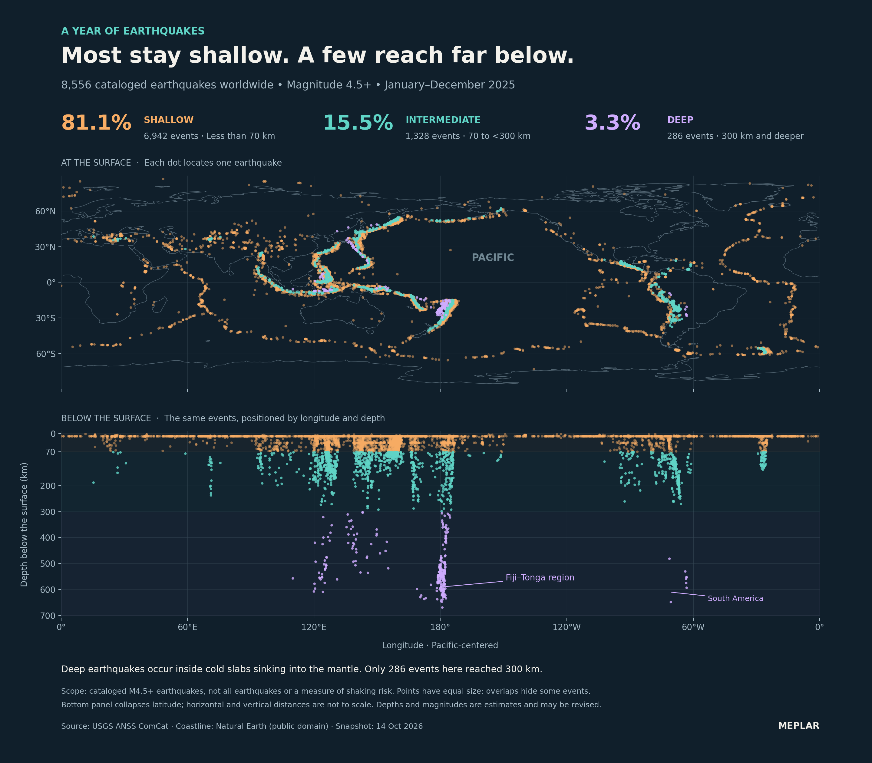
Of the 8,556 cataloged magnitude 4.5+ earthquakes in this 2025 USGS snapshot, 81.1% were shallower than 70 km and 3.3% reached at least 300 km.
The depth groups contain 6,942 shallow, 1,328 intermediate and 286 deep events. The deepest in this selection is 669.556 km. These counts describe the selected catalog events, including aftershocks; they do not measure shaking risk, energy or human impacts.
Worldwide USGS ComCat earthquakes with preferred magnitude ≥4.5 and origin time from 1 January 2025 inclusive to 1 January 2026 exclusive, UTC.
How it was made
Preserve every returned USGS CSV row, including aftershocks; assert unique IDs, reviewed status, required values, magnitude ≥4.5, nonnegative depth and the half-open 2025 UTC interval. Rename key fields and add event links. Classify depth into [0,70), [70,300) and [300,infinity) km, with shares divided by all 8,556 selected events.
Definitions & limits
- This is the cataloged magnitude ≥4.5 selection, not all global earthquakes. Detection, catalog practices, magnitude types and location precision vary; uniform global completeness is not claimed.
- Aftershocks are included, so events are not independent tectonic episodes. Preferred magnitude types and contributing network/source fields are retained; magnitude is not converted to energy.
- Some depths may be constrained or defaulted. Error fields remain in the CSV, while plotted point estimates omit uncertainty intervals. Source precision does not establish physical certainty; future catalog revisions can change values or threshold membership.
- The map is a schematic longitude–latitude coastline view, not an equal-area projection. The lower panel collapses all latitudes into longitude versus depth; it is not a physical cross-section and cannot establish slab dip or layer thickness. Horizontal and vertical distances are not to scale.
- All points have equal marker area; color represents depth rather than magnitude and overlaps hide points. Depth ranges are shallow <70 km, intermediate 70–<300 km, and deep ≥300 km.
- All 8,556 events have reviewed status in this snapshot. The independent API count matches the CSV, below the 20,000-event ceiling; origin times are explicitly checked to be before the end boundary. Rounded image percentages sum to 99.9%.
- Credit USGS ANSS ComCat and contributing seismic networks. Coastline: Natural Earth. Neither source endorses this original Meplar graphic; retain attribution and source fields when redistributing.
Original sources
- USGS ANSS ComCat query, 2025 magnitude 4.5+
- USGS ComCat documentation
- USGS earthquake depth definitions
- Natural Earth coastline
Snapshot date: 2026-10-14. Source releases and observations can be revised; the linked download notes describe this fixed version.